
Topography, Land and Soil Surveys

Important parts of our building project are the Topography, Land, and Soil studies. This was an exciting weekend; we met with the topographer, architect, civil engineer and the soil surveyor at our lot.
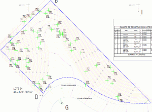
The topographer spent about a week getting all the exact points of reference and defined the border lines of the lot. Downloaded these data via GPS satellite. It recorded the land’s steepness and identified all major trees. Based on these data and the zoning laws and rules, a defined perimeter was proposed to build.
This photo is a satelite image of our lot with the blue lines pointing the perimeter. The following image shows the elevation of each lot area and the main trees marked by type of tree and height. Remember this is extremely important as mentioned in this other posting.
We shared this topography information with the Land & Soil surveyor so that he has an idea of which parts of the soil will need to be studied. The surveyor will be digging at 4 to 5 holes at different points on the lot at apprximatelly 4 meters depth each hole. Soil sample will be taken to a lab to analyze its composition to determine how stable is the land to build on. So many people try to cut corners to save money in the short-run only to regret it later. These topography and soil surveys are well worth the investment to save you from potential disastrous building decisions.
Next step will be for us to complete the initial architectural layout with measures and render it within the proposed building location. This information will be passed to the Land & Soil surveyor so that he can perform the survey. We are looking this to be complete between the end of 2018.
We will be spending our end of 2018 vacation in Puerto Vallarta and San Pancho. It will be the first time our kids will get to see our lot and they are very excited.
If you enjoyed reading this article, please recommend and share it to help others find it!
Hello – I am in a very similar situation to what you described and I could use a land surveyor to come out and identify the four corners of a lot we recently purchased in Litibú (about halfway between Bucerías and Sayulita). Would you please email me the contact information of the surveyor you used?
Thank you.